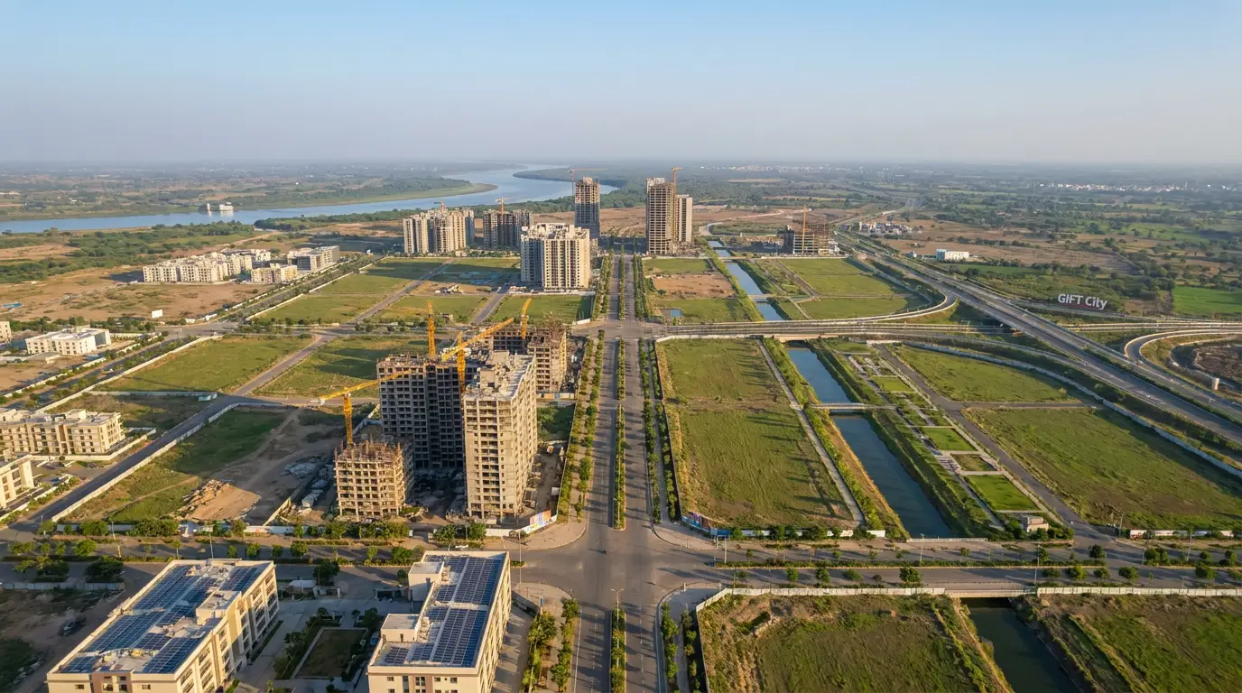
Dholera SIR is the Dholera Special Investment Region, a large greenfield city being built from scratch on the coast of Gujarat, about 100 km south-west of Ahmedabad. It covers a planned area of roughly 920 sq km under the Gujarat Special Investment Region Act, 2009, and it is developed as a flagship node of the Delhi-Mumbai Industrial Corridor (DMIC). It is planned and built by two public bodies, DSIRDA and DICDL, and its first fully serviced patch is the roughly 22.5 sq km Activation Area. It is marketed as Dholera Smart City, though most of the region is still farmland and future construction.
Dholera SIR is the Dholera Special Investment Region, a greenfield city being planned and built from scratch on the western coast of the Gulf of Khambhat in Gujarat, roughly 100 km south-west of Ahmedabad. It is set up under the Gujarat Special Investment Region Act, 2009, spans a planned area of about 920 sq km, and is developed as a flagship node of the Delhi-Mumbai Industrial Corridor (DMIC). It is widely marketed as Dholera Smart City. This page explains what the term actually means, where the land is, which laws and agencies sit behind it, and what has been built so far, using only sourced figures.
Dholerapedia is an independent, neutral reference. It does not sell plots and takes no money to promote anyone. Where a figure is a target or a reported claim rather than a settled fact, this page says so.
What does Dholera SIR stand for?
SIR stands for Special Investment Region. The full name is the Dholera Special Investment Region. A Special Investment Region is a large, planned investment zone created and governed under a specific Gujarat law, not the same thing as a private township or a single SEZ. The label matters because it defines who has planning authority over the land and how it is developed. For a deeper breakdown of the term, see our explainer on the Dholera SIR full form. The marketing name Dholera Smart City refers to the same project, which we unpack in Dholera Smart City explained.
Where is Dholera?
Dholera sits in Dholera taluka of Ahmedabad district, formed from 22 villages on flat, low-lying coastal land locally known as the Bhal. It faces the western coast of the Gulf of Khambhat (Cambay). It is roughly 100 km south-west of Ahmedabad and is now linked to the city by the roughly 109 km Ahmedabad-Dholera Expressway. The terrain is a real planning factor: about a third of the developable land falls within the Coastal Regulation Zone, and drainage on tidal flats is a documented constraint the master plan has to design around.

The legal basis: the Gujarat SIR Act, 2009
Dholera's legal foundation is the Gujarat Special Investment Region Act, 2009. This is the state law that lets Gujarat notify a large area as a Special Investment Region and vest planning, development and land-management powers in a dedicated authority rather than the usual local bodies. That is what separates a SIR from an ordinary municipal area or a private real-estate scheme. Our page on the SIR Act 2009 covers what the Act actually empowers and why the region is structured the way it is.
Who governs Dholera SIR?
Three bodies do most of the work, and it helps to keep them separate:
- DSIRDA is the statutory planning and land authority for the region, responsible for the master plan and Town Planning schemes.
- DICDL, or Dholera Industrial City Development Ltd, is the special purpose vehicle that actually builds the city. It was incorporated on 28 January 2016 and is owned 51% by the Gujarat government (through DSIRDA) and 49% by the central government (through the NICDC Trust).
- NICDC, the National Industrial Corridor Development Corporation (formerly DMICDC), is the central nodal agency for the wider corridor.
| Body | Role | Key detail |
|---|---|---|
| DSIRDA | Statutory planning and land authority | Owns the master plan and TP schemes; holds Gujarat's stake in DICDL |
| DICDL | Development SPV that builds the city | Incorporated 28 January 2016; Gujarat 51% / Centre 49% |
| NICDC | Central nodal agency for the corridor | Formerly DMICDC; anchors the DMIC programme |
For fuller profiles, see the Dholera development authority (DSIRDA) and what DICDL is.
Dholera as a DMIC node
Dholera is one of the industrial nodes planned along the Delhi-Mumbai Industrial Corridor, the freight-and-industry corridor anchored on a dedicated rail line between the two cities. It is frequently described as the largest node of the DMIC. The size claim is a reported superlative rather than an independently settled fact, so we present it as reported. What is not in dispute is that Dholera is a flagship node of the programme, which is why it draws central as well as state funding. See the DMIC explained for how the corridor works.
The Activation Area and phasing
The whole 920 sq km is not being built at once. The first serviced patch is the Activation Area, about 22.5 sq km inside Town Planning Scheme 2, which is the plug-and-play demonstration zone carrying the first trunk roads, underground utilities and the ABCD command building. Of the roughly 920 sq km planned envelope, around 580 sq km is reported as developable and about 422 sq km as urban, with the rest constrained by the Coastal Regulation Zone. The chart below shows those reported areas. An old 2020 target of about 120,000 residents and 80,000 jobs in the Activation Area has since lapsed, which is a useful reminder that early timelines here have moved.
What is being built so far
On the ground in mid-2026, the visible anchors are real but early. The Ahmedabad-Dholera Expressway was reported inaugurated on 31 March 2026. The Tata Electronics semiconductor fab, approved at about Rs 91,000 crore under the India Semiconductor Mission, is under construction. Part of the Dholera solar park is operational, with roughly 300 MW commissioned against a much larger long-range target. The Dholera International Airport is under construction with its opening still a target. Beyond these anchors, most of the region is farmland and future Town Planning schemes, so it is best understood as an infrastructure story running ahead of a living-city story. The full sequence is laid out in the Dholera timeline, and the underlying numbers sit in Dholera data.
Frequently asked questions
What is Dholera SIR in simple terms?
Where exactly is Dholera SIR?
How big is Dholera SIR?
Who runs and builds Dholera?
Is Dholera the same as Dholera Smart City?
Is Dholera fully built?
DholeraPulse. (2026). What Is Dholera SIR? The Complete, Sourced Explainer. Retrieved 22 July 2026, from https://dholerapulse.com/what-is-dholera-sir.htmlSources & references
- Dholerapedia Fact Pack, 2026 (planned ~920 sq km, developable ~580, urban ~422, Activation Area ~22.5 sq km, SIR Act 2009, DSIRDA/DICDL/NICDC, DMIC node)
- dholera.gujarat.gov.in/about_us (region, governance)
- nicdc.in, Dholera SIR node pages
- Gujarat Special Investment Region Act, 2009
- Dholerapedia pillar pages: Activation Area, DMIC explained, Ahmedabad-Dholera Expressway
DholeraPulse labels facts by confidence. Figures marked reported or target come from press or announcements and may change; verify anything time sensitive against the official source before acting.